India Cyclone Murasu Weakens After Causing Major Damage
India cyclone Murasu has weakened after sweeping across Andhra Pradesh, but its impact remains widespread. The storm damaged agricultural land, disrupted transport and power supplies, and forced thousands of residents into temporary shelters. Here’s the latest on the storm’s impact and recovery efforts.

India cyclone Murasu weakened after hitting Andhra Pradesh
Cyclone Murasu: Key Facts at a Glance
-
Storm name: Cyclone Murasu
-
Landfall: Near Ongole, Andhra Pradesh
-
Landfall date: November 3, 2026
-
Wind speed: 100–110 km/h
-
Maximum gusts: Up to 120 km/h
-
Fatalities: At least 2
-
Agricultural damage: 52,459 hectares
-
Estimated losses: Rs 344 crore
India Cyclone Murasu Damaged Andhra Pradesh
Cyclone Murasu moved across India's eastern coastline near Ongole, in Andhra Pradesh's Prakasam district, at around 1 a.m. local time on November 3, 2026.
The storm made landfall with sustained winds of 100–110 km/h and gusts reaching 120 km/h, according to the India Meteorological Department (IMD).
Several coastal areas experienced intense rainfall and strong winds as the system moved inland.
Fallen trees, damaged electricity poles and flooded roads disrupted daily activities in affected communities.
Low-lying areas faced additional flooding concerns as heavy rain continued.
The storm gradually weakened after crossing the coast.
By Tuesday afternoon, it had downgraded from a severe cyclonic storm to a cyclonic storm, with sustained winds falling to 80–90 km/h.
The IMD expected further weakening into a deep depression by midnight.
Although Murasu lost strength, continued rainfall remained a concern for coastal districts.
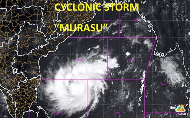
Radar shows an image of Cyclone Murasu approaching Andhra Pradesh and Odisha (Photo: IMD)
Check storm on radar on GoWeatherRadar!
Agricultural Losses and Infrastructure Disruptions
The impact of Cyclone Murasu extended beyond coastal flooding, with agriculture and essential services among the hardest-hit sectors.
|
Category |
Reported Damage |
|
Agricultural land |
52,459 hectares affected |
|
Estimated losses |
Rs 344 crore |
|
Houses |
312 damaged |
|
Electricity poles |
Around 2,750 damaged |
|
Rail services |
35+ trains cancelled |
|
Fatalities |
At least 2 |
Source: Andhra Pradesh disaster management reports, November 3, 2026.
State disaster management officials confirmed at least two deaths linked to the storm.
Initial assessments placed the estimated financial losses at approximately Rs 344 crore.
Around 52,459 hectares of standing crops across 15 districts suffered damage, while 312 houses were affected.
Krishna, Bapatla and Nandyala were among the districts reporting significant agricultural losses.
Electricity infrastructure also sustained considerable damage. Approximately 2,750 power poles were damaged, alongside transmission lines, substations and distribution equipment.
These disruptions left restoration teams with a major repair task across affected communities.
Transport services faced further interruptions as severe weather affected rail and air operations.
More than 35 trains were cancelled, 14 were diverted and eight were rescheduled. Several flights were also cancelled due to unfavorable weather conditions.
The damage forced thousands of residents to leave their homes.
Around 12,230 people were staying in designated cyclone shelters while authorities assessed affected areas and organized relief assistance.
Andhra Pradesh Starts Recovery, Odisha Maintains Vigilance
Authorities in Andhra Pradesh continued emergency operations after the cyclone weakened.
Eleven National Disaster Response Force (NDRF) teams and 13 State Disaster Response Force (SDRF) teams were deployed to assist affected communities.
Another 185 Fire Department teams supported road clearance, debris removal and floodwater drainage.
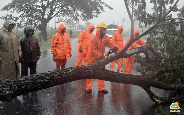
Indian authorities continue rescue and recovery work (Photo: Press Trust of India)
Neighboring Odisha also remained prepared for possible weather-related disruptions. Although rainfall was relatively lighter in its southern districts on November 3, authorities had evacuated more than 165,000 residents to safer locations.
The state arranged 592 temporary and permanent shelters across five southern districts and deployed emergency personnel to monitor vulnerable communities.
Local officials continued coordinating evacuation and relief measures as the storm moved farther inland.
While Murasu had weakened considerably, the risk of additional rainfall remained important for areas already affected by flooding and infrastructure damage.
Check precipitation and wind radar layers for Bapatla on RadarMap to follow changing weather conditions and monitor potential rainfall across the affected district.
References
-
India Today
-
India Express
-
AP News
-
Al Jazeera





0 Comments
Leave a Comment
Your email address will not be published. Required fields are marked *