A La Niña Winter Is Coming. Here Are What You Should Know About It
A mild La Niña is likely to impact temperatures, precipitation, and snowfall in the US.
La Niña is a natural climatic pattern characterized by lower-than-average ocean temperatures in the equatorial Pacific. The impacts on weather are most prominent in the Northern Hemisphere's winter months, with much less influence in the summer.
 A La Niña winter is coming
Last winter was the hottest on record for the Lower 48 owing to La Niña's counterpart–El Niño, and global warming caused by fossil fuel pollution.
The extended warmth weather prevented several major snow occurrences in the Northeast and Midwest, resulting in a winter snow drought measured in feet of missed snow.
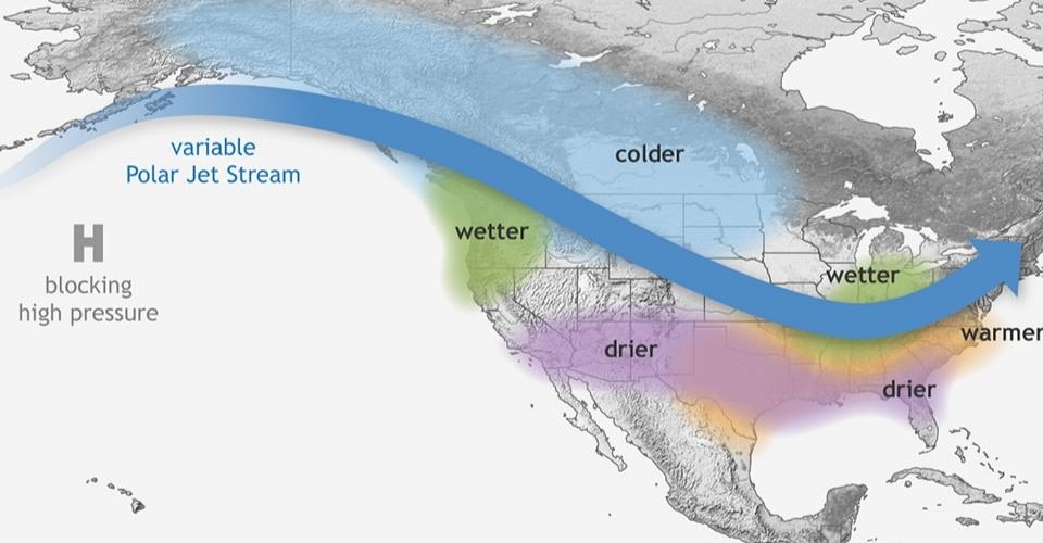
According to the Climate Prediction Center, La Niña is expected to emerge by November with a 60% chance. Once it arrives, it is expected to remain for the whole winter and maybe into early spring of the next year.

What could this winter look like?
Although each La Niña winter is unique, there are general trends in temperature and precipitation.
The whole northern tier of the United States is projected to be wetter than usual this winter, particularly the Pacific Northwest, Midwest, and portions of the interior Northeast.
Wet weather will be essential in combating prolonged dryness and drought in the Midwest.
Greater precipitation than average does not ensure greater snow. Temperatures must be cold enough both above and below the surface for snow to fall and cling to the ground.
If this year's La Niña is weak, the forecast might change. However, the most recent winter temperature predictions from the center are not favorable for snow lovers in the Northeast.
Read next:


0 Comments
Leave a Comment
Your email address will not be published. Required fields are marked *