Fall Heat Wave Brings Unseasonable Warmth Before a Weekend Chill
A fall heat wave is making mid-October feel more like summer across the central and eastern United States. Temperatures are climbing into the 90s in several areas, with some locations nearing daily records. However, a powerful cold front is expected to end the unusual warmth later this week. Here’s what to expect as temperatures begin to fall.

Fall heat wave in the central and eastern United States
KEY TAKEAWAYS FOR THIS WEEK
-
Peak Heat: Monday – Wednesday (Hundreds of daily record highs broken).
-
Impact: Over 250 million people across 20+ states.
-
The Drop: Sudden 40°F plunge starting Thursday evening.
-
Coldest Night: Sunday morning with widespread freeze/frost warnings.
Fall Heat Wave Sweeps the US Ahead of a Sharp Cooldown
The central and eastern United States are facing another stretch of unusually fall heat wave, with more than 20 states expected to experience above-average temperatures.
The heat could affect over 250 million Americans across the Great Plains, Midwest, Mid-South and Southeast.
A broad area of high pressure is keeping warm air in place, allowing afternoon temperatures to climb into the upper 80s and 90s.
Parts of the Southern Plains and Southeast could reach the mid- to upper 90s, while humidity may push heat index values above 100°F in some southern locations.
Several cities could also see daily temperature records challenged.
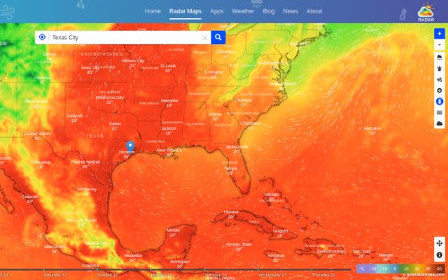
GoWeatherRadar's radar map shows the current temperature distribution across Southern Plains
More on Temperature radar map
The summer-like conditions are expected to ease as a dip in the jet stream helps drive a strong cold front across the country later this week.
Temperatures could drop by as much as 40°F from midweek levels in some areas, bringing a return to more typical fall weather.
The cooling trend may also bring chilly nights and early-morning frost.
Parts of the Upper Midwest and Central Great Plains face frost concerns, while some inland areas of the Northeast could see temperatures near or below freezing.
The timing and severity of the cold will vary by location.
🚨 Health & Safety: Quick Tips for the 40°F Swing
- Health: Rapid temperature drops can trigger cold symptoms or respiratory stress. Dress in layers as the weather shifts from summer-like heat to crisp weekend air.
- Plants: Cover sensitive vegetation or bring potted plants indoors by Friday night to protect them from weekend frost.
- Home & Car: Test your home heating system and check your vehicle's tire pressure, as cold air causes pressure to drop.
In Baton Rouge, Louisiana, afternoon highs are forecast to reach the low 90s during the workweek, compared with typical October highs in the low 80s.
The cold front is expected to arrive late Friday, bringing breezier conditions and a temperature drop of around 10–15°F.
Saturday highs may remain below 80°F, with Sunday morning lows falling into the mid-50s.
Rain is unlikely across parts of southern Louisiana and southwestern Mississippi in the coming days.
The lack of rainfall could further worsen drought conditions, even as cooler air arrives.
Explore precipitation and wind patterns on RadarMap to monitor local weather changes!
Residents should continue checking local forecasts as the transition from unusual heat to cooler fall weather unfolds.
Those in frost-prone areas should pay particular attention to overnight temperatures heading into the weekend.
References
-
FOX Weather
-
WAFB





0 Comments
Leave a Comment
Your email address will not be published. Required fields are marked *