El Nino is a virtual lock to develop by summer[NOAA’s Outlook]
The National Oceanic and Atmospheric Administration’s Climate Prediction Center (CPC) is keeping an eye out for El Nino and provides monthly updates that explain how they interpret trending weather data and reveal it to the rest of us.
A few key disclosures were mentioned in the study they gave, including the potential of an El Nino event this year, when they anticipate it to begin, and how long it might stay.
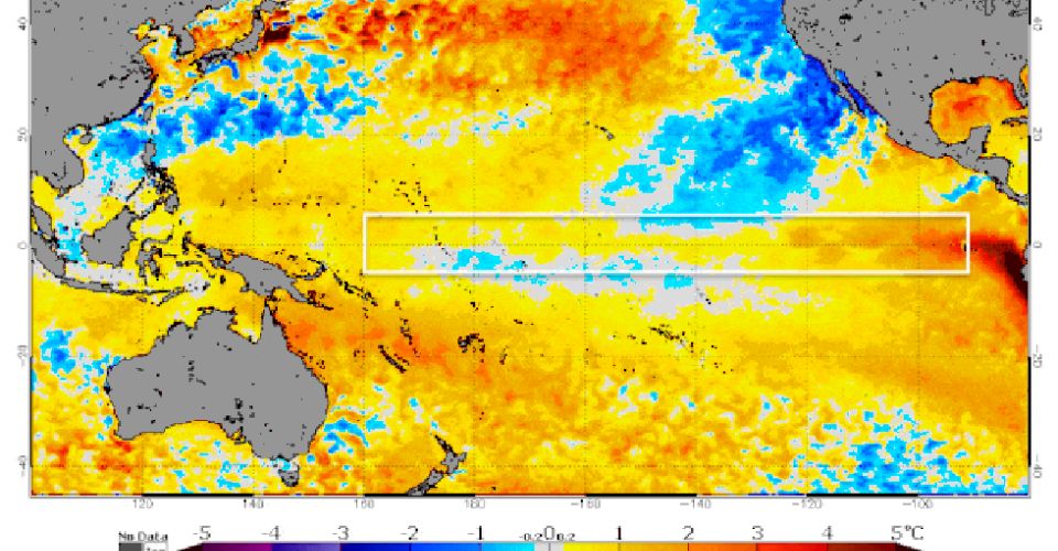
NOAA's CPC continued its El Nino watch
Also read | Meteorologists Anticipate A Quick Transition To Summer
NOAA now anticipates El Nino to form within the upcoming 90 days ("during the May - July season") and persist through the winter.
With the possibility of a "significant" El Nino on the horizon and at least a weak El Nino later in the year (November - January), it might all begin as early as this month.
According to their predictions, there is an 80% possibility of at least a moderate El Nino and a 55% chance it will be a strong event.
Yet, there is still a 5 - 10% chance that none of this happens at all, leaving the door open for a calm rest of the year.
Still, NOAA reports a greater than 90% chance that something will materialize within the next few months or even weeks. El Nino is expected to last into the Northern Hemisphere winter.
Their previous report, which was given a month ago, predicted that things would start to turn around by August.
NOAA's Dr. Mike McPhaden stated in April that "we're due one."
Nevertheless, the expected El Nino's magnitude "shows a very large spread, everything from blockbuster to wimp."
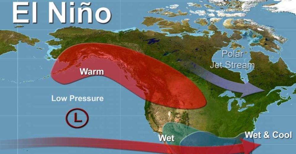
El Nino
How were these forecasts made?
An El Nino is officially recognized when sea surface temperatures in particular regions of the Pacific Ocean are at least .5 degrees Celsius above average for at least one month and are anticipated to last for several more months.
This completes the puzzle of an El Nino by affecting the atmosphere, as is only natural. There is no El Nino if the ocean temperatures are above average without having the anticipated effect on the atmosphere.
In fact, the water has recently been warm around this stretch of the equator, indicating the initial elements of the equation are currently in effect.
Additionally, many meteorologists have allegedly noted that compared to similar times in 1982 and 1997, both of which saw significant El Ninos, the current sea-surface temperatures are trending warmer.
The following set of monthly information from NOAA must wait another month. However, at that time, El Nino could already be in full force.
Get the most up-to-date information by following Go Weather Radar!


0 Comments
Leave a Comment
Your email address will not be published. Required fields are marked *