Four Corners flooding continues to threaten the Southwest as more storms move into the region. Rivers are beginning to fall in some areas, but evacuation orders, damaged infrastructure, and renewed rainfall risks are keeping emergency crews on alert.

Four Corners flooding
Takeaways
-
Additional rainfall could trigger renewed flooding across the Four Corners region.
-
Evacuations, power outages and infrastructure damage continue around Farmington and Shiprock.
-
Contaminated floodwater and damaged utilities remain hazards even as water levels fall.
Four Corners Flooding Put Region on Alert
The Four Corners region faced another round of potential flooding on Sunday, October 25, 2026, after several days of heavy rain across the southwestern United States.
The National Weather Service (NWS) issued a flood watch for much of the area, where Arizona, Colorado, New Mexico and Utah meet.
Officials warned that additional showers and thunderstorms could worsen conditions, even as some rivers began to recede.
Rainfall intensified around Wednesday, October 21, sending rivers and streams rising and forcing evacuations and water rescues.
With the ground already saturated, further rain could quickly overwhelm small creeks and drainage channels.
Low-lying communities and areas near rivers remain particularly vulnerable to renewed flooding.
The severe weather also brought a tornado to Santa Fe, New Mexico, on Saturday evening. Meteorologists were investigating whether other tornadoes had touched down elsewhere in the state.
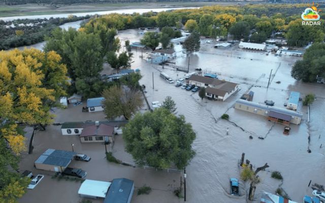
Severe flooding in the Four Corners community (Photo: KOB4)
Residents can check storm movement and precipitation on the Radar Map by locating Santa Fe on the map and reviewing the available radar layers.
Tracking approaching rain can help residents stay aware of changing conditions, but official warnings should guide emergency decisions.
New Mexico Communities Face Damage and Disruptions
Flooding continued to disrupt daily life around Farmington in northwestern New Mexico.
Although water levels were falling in some locations, residents remained evacuated and hundreds of people were still without electricity on Sunday.
San Juan County officials had not confirmed the full number of damaged homes or evacuees, and no deaths had been reported in the county at that time.
The damage reached residential areas and essential infrastructure.
San Juan County Sheriff Shane Ferrari said floodwater had entered his home to a depth of about 4 feet (1.2 meters).
Emergency personnel were inspecting evacuated neighborhoods for downed power lines, damaged utility connections and other hazards before allowing residents to return.
Further downstream, flooding damaged wastewater facilities and holding ponds in Shiprock, within the Navajo Nation.
The damage resulted in sewage entering the San Juan River, although officials had not established the total amount released.
In Colorado's Archuleta County, emergency teams conducted welfare checks and aerial surveys to determine the extent of the destruction.
Officials described the damage as severe, while assessments were still underway.
|
Flood Safety Tips: How to Stay Safe
|
Falling river levels do not necessarily mean the danger has passed.
Saturated soil can increase runoff from new storms, while floodwater may leave behind sewage, contaminated sediment and damaged gas or electrical lines.
Officials also warned that inspections and repairs could take several days, delaying the safe return of evacuated residents.
People should avoid flooded roads and restricted neighborhoods, follow emergency instructions and monitor NWS alerts for updated warnings.
References
-
NBC News
-
ABC News
-
AP News
-
WRAL





0 Comments
Leave a Comment
Your email address will not be published. Required fields are marked *