First Nor’easter of the Season: What to Expect and When?
A powerful atmospheric system is stirring off the Atlantic coast, marking the official arrival of the first nor'easter of the season. This slow-moving autumn storm threatens millions with torrential rainfall, severe gale-force winds, and destructive beach erosion. As tidal waters rise, coastal communities must brace for extended disruptions. Here's the latest update on what to expect.

First Nor’easter of the season is taking shape
Takeaway
-
A developing first nor'easter of the season is taking shape offshore, unleashing strong winds, heavy precipitation, and severe coastal inundation.
-
Blocked by a high-pressure system to the north, the storm will linger over coastal waters for multiple days rather than passing quickly.
-
Weather hazards will sweep northward over the week, starting in North Carolina before extending toward the Mid-Atlantic and New England.
First Nor'easter of the Season Brews Over the Atlantic
Autumn is making a dramatic entrance as the first nor'easter of the season gathers strength off the Atlantic Seaboard.
Following an unusually quiet summer along the eastern shoreline, meteorologists are watching this substantial fall storm closely as it expands across the coastal region.
The storm is developing through the clash of two major air masses: a expanding low-pressure zone near the Carolinas and a solid high-pressure ridge stationed over eastern Canada.
This setup creates a tight pressure gradient that drives powerful, relentless winds straight from the northeast.
The Canada-based high-pressure system acts as a atmospheric wall, stalling the storm’s movement and prolonging its impact on coastal communities before it eventually drifts northward.
Because the system is locked in place, coastal hazards will endure over an extended period.
Daytime temperatures across the Mid-Atlantic and Northeast will drop to crisp autumn levels, mostly staying in the 50s to 60s, while raw winds and heavy surf remain the dominant weather features.
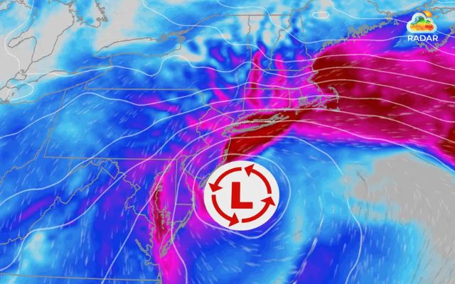
First Nor’easter of the season strengthens along the Atlantic Seaboard (Source: The Weather Channel)
Storm Timeline and Predicted Regional Impacts
Since the system moves at a sluggish pace, different parts of the East Coast will encounter peak storm conditions at different stages of the week.
Early Week: North Carolina and the Southeast
The earliest disturbances arrive along North Carolina’s Outer Banks and neighboring shores.
Sustained northeasterly winds reaching 40 to 50 mph will pump offshore ocean swells up to 18 feet.
Pounding waves across consecutive high tides will trigger widespread beach erosion, serious coastal inundation, and ocean overwash onto vulnerable coastal thoroughfares such as Highway 12.
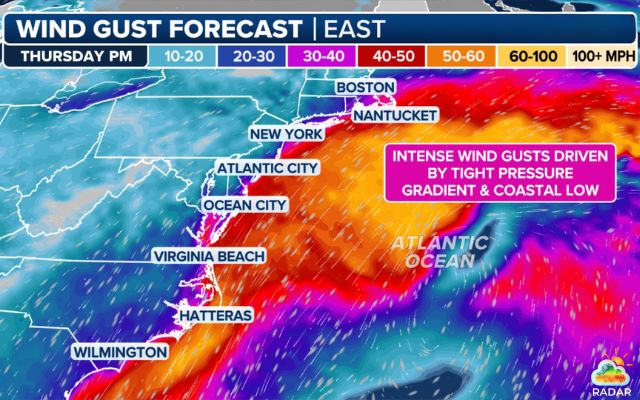
Wind gust forecast from FOX Weather
Check live wind radar on GoWeatherRadar before traveling near low-lying roads.
Mid to Late Week: Mid-Atlantic and New Jersey Shores
From Thursday into Friday, persistent onshore airflow will push marine waters inland, filling back bays and estuaries from Virginia up through New Jersey.
Wind gusts will average 30 to 40 mph, with tide levels building toward moderate or major flood thresholds over several tidal cycles.
Rain conditions will depend on how close the center of the low sweeps past the shoreline.
|
FLOOD SAFETY TIPS
|
The Weekend: New England and Atlantic Canada
As the weekend approaches, the storm shifts its sights toward New England and Atlantic Canada. Meteorology teams highlight Boston as a primary zone to watch.
A track closer to the coast could unleash wind gusts between 60 and 70 mph, heavy downpours, and significant surge around Boston Harbor.
Meanwhile, southern New Brunswick and Nova Scotia can expect gusty conditions and soaking rain starting late Friday.
In the path of the New England storm? Track live rain bands and severe weather alerts for Boston and the Northeast on RadarMap to stay informed.
Coastal Hazards and Essential Safety Steps
Repeated coastal flooding and turbulent sea conditions represent the primary risks during this multi-day weather event.
Persistent winds prevent trapped bay waters from receding, leading to cumulative flooding with each subsequent high tide.
High surf will also erode shorelines and damage beach structures.

A house is about to collapse in New Jersey due to a Nor’easter in Oct.2025 (Photo: Allison Joyce/AP)
Local officials encourage coastal residents to tie down loose outdoor objects and prepare for potential utility outages caused by wind-damaged tree limbs.
Never attempt to drive through water-covered roadways, as coastal flooding can surge unexpectedly during high tide.
Swimmers and boaters should refrain from entering the water due to hazardous currents and massive breaking waves.
Stay tuned to local weather updates and regularly check rain radar as subtle path adjustments can alter local rain and wind totals.
References
-
FOX Weather
-
The Weather Network
-
North Jersey





0 Comments
Leave a Comment
Your email address will not be published. Required fields are marked *